
NOAA
after one week devastating storm ida tera hit the United States, another intense hurricane (category 3 to 5) acts in the North Atlantic. This is Larry. The good news is that, unlike Ida, Larry is well off the coast in open water and shouldn’t be at risk for densely populated areas. However, the storm is expected to pass dangerously close to Bermuda.
Larry is currently a Category 3 hurricane and is expected to progress to Category 4 early this week. This Sunday afternoon, the cyclone was located at 20.1°N and 50.2°W with sustained winds of approximately 180 km/h and minimum central atmospheric pressure of 955 hPa.
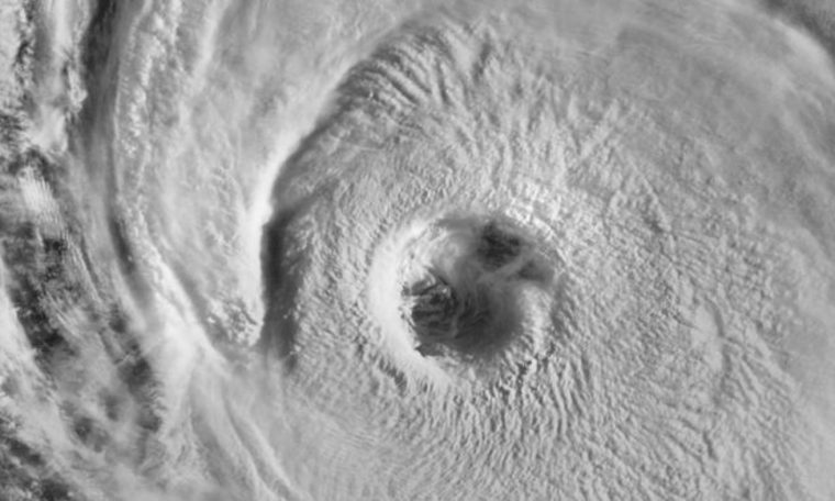
The structure of the storm caught the attention of meteorologists throughout this weekend, with a very concentrated and at times very well-defined look. This Sunday, part of the eyewall has become less settled with a large shear pattern.
3D Infrared Satellite Loop of Major Hurricanes #larry. It is a large storm with hurricane force winds extending up to 45 miles from the center and tropical storm force winds extending up to 175 miles.
loop etiquette @RadarOmega Application pic.twitter.com/HV8Aw62vGc
— Colin Gross (@CollinGrossWx) September 5, 2021
Here’s a mesmerizing view of Major Hurricane #larryThis morning’s eye over the past hour, using 1-minute GOES-16 visible imagery. pic.twitter.com/uByfKuUV3C
— NWS Corpus Christi (@NWSCorpus) September 5, 2021
Big ️ of . at sunrise #larry pic.twitter.com/9EUgGxIifT
— Stu Ostro (@StuOstro) September 5, 2021
The storm is predicted to generate large waves with large waves that hit the Lesser Antilles and then spread west to parts of the Greater Antilles, the Bahamas and Bermuda.
[8:30pm EDT 9/4/2021] Hurricane Larry – Peak seas are currently near 42 feet and will reach 48 feet by Monday. Big swell to reach the Leeward Islands tonight. pic.twitter.com/MrPJavMGGK
— NHC_TAFB (@NHC_TAFB) September 5, 2021
Significant waves are expected to hit the east coast of the United States during the week, and numerical models also indicate that Larry’s swell will reach the coasts of Para, Amapá and Maranho in Brazil with greater sea movement.
Models indicate waves of up to 15 meters near the center of the storm, but we stress that if the swelling reaches the northern coast of Brazil, the sea rise will not be significant compared to other regions.
The 2021 Atlantic hurricane season has already generated 38 named hurricane days. Only six years (since 1966) in the age of the satellites had more hurricane days, lasting September 4, 1995, 1996, 2005, 2008, 2012 and 2020.
Larry is the third intense hurricane in the 2021 Atlantic season. Only three other Atlantic seasons until September 4, 1933, 2005 and 2008 had 3 hurricanes with maximum winds near 200 km/h.


